- British Indian Ocean Territory
-
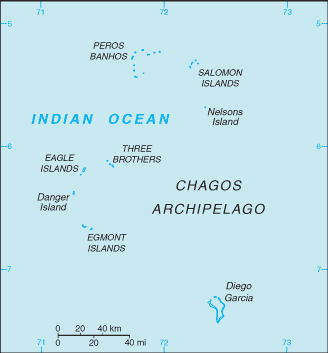 Introduction ::British Indian Ocean TerritoryBackground:Formerly administered as part of the British Crown Colony of Mauritius, the British Indian Ocean Territory (BIOT) was established as an overseas territory of the UK in 1965. A number of the islands of the territory were later transferred to the Seychelles when it attained independence in 1976. Subsequently, BIOT has consisted only of the six main island groups comprising the Chagos Archipelago. The largest and most southerly of the islands, Diego Garcia, contains a joint UK-US naval support facility. All of the remaining islands are uninhabited. Between 1967 and 1973, former agricultural workers, earlier residents in the islands, were relocated primarily to Mauritius, but also to the Seychelles. Negotiations between 1971 and 1982 resulted in the establishment of a trust fund by the British Government as compensation for the displaced islanders, known as Chagossians. Beginning in 1998, the islanders pursued a series of lawsuits against the British Government seeking further compensation and the right to return to the territory. In 2006 and 2007, British court rulings invalidated the immigration policies contained in the 2004 BIOT Constitution Order that had excluded the islanders from the archipelago, but upheld the special military status of Diego Garcia. In 2008, the House of Lords, as the final court of appeal in the UK, ruled in favor of the British Government by overturning the lower court rulings and finding no right of return for the Chagossians.Geography ::British Indian Ocean TerritoryLocation:archipelago in the Indian Ocean, south of India, about halfway between Africa and IndonesiaGeographic coordinates:6 00 S, 71 30 E; note - Diego Garcia 7 20 S, 72 25 EArea:total: 54,400 sq kmcountry comparison to the world: 128land: 60 sq km; Diego Garcia 44 sq kmwater: 54,340 sq kmnote: includes the entire Chagos Archipelago of 55 islandsArea - comparative:land area is about 0.3 times the size of Washington, DCLand boundaries:0 kmCoastline:698 kmMaritime claims:territorial sea: 3 nmexclusive fishing zone: 200 nmClimate:tropical marine; hot, humid, moderated by trade windsTerrain:flat and low (most areas do not exceed two meters in elevation)Elevation extremes:lowest point: Indian Ocean 0 mhighest point: unnamed location on Diego Garcia 15 mNatural resources:coconuts, fish, sugarcaneLand use:arable land: 0%permanent crops: 0%other: 100% (2011)Natural hazards:NAEnvironment - current issues:NAGeography - note:archipelago of 55 islands; Diego Garcia, largest and southernmost island, occupies strategic location in central Indian Ocean; island is site of joint US-UK military facilityPeople and Society ::British Indian Ocean TerritoryPopulation:no indigenous inhabitantsnote: approximately 1,200 former agricultural workers resident in the Chagos Archipelago, often referred to as Chagossians or Ilois, were relocated to Mauritius and the Seychelles in the 1960s and 1970s; in November 2004, approximately 4,000 UK and US military personnel and civilian contractors were living on the island of Diego GarciaGovernment ::British Indian Ocean TerritoryCountry name:conventional long form: British Indian Ocean Territoryconventional short form: noneabbreviation: BIOTDependency status:overseas territory of the UK; administered by a commissioner, resident in the Foreign and Commonwealth Office in LondonLegal system:the laws of the UK, where applicable, applyExecutive branch:chief of state: Queen ELIZABETH II (since 6 February 1952)head of government: Commissioner Colin ROBERTS (since July 2008); Administrator John MCMANUS (since April 2011); note - both reside in the UK and are represented by the officer commanding British Forces on Diego Garciacabinet: NA(For more information visit the World Leaders website )elections: none; the monarchy is hereditary; commissioner and administrator appointed by the monarchDiplomatic representation in the US:none (overseas territory of the UK)Diplomatic representation from the US:none (overseas territory of the UK)Flag description:white with six blue wavy horizontal stripes; the flag of the UK is in the upper hoist-side quadrant; the striped section bears a palm tree and yellow crown (the symbols of the territory) centered on the outer half of the flag; the wavy stripes represent the Indian Ocean; although not officially described, the six blue stripes may stand for the six main atolls of the archipelagoEconomy ::British Indian Ocean TerritoryEconomy - overview:All economic activity is concentrated on the largest island of Diego Garcia, where a joint UK-US military facility is located. Construction projects and various services needed to support the military installation are performed by military and contract employees from the UK, Mauritius, the Philippines, and the US. Some of the natural resources found in this territory include coconuts, fish, and sugarcane. Sugarcane is still a major export for this territory. There are no industrial or agricultural activities on the islands. The territory earns foreign exchange by selling fishing licenses and postage stamps.Exchange rates:the US dollar is usedCommunications ::British Indian Ocean TerritoryTelephone system:general assessment: separate facilities for military and public needs are availabledomestic: all commercial telephone services are available, including connection to the Internetinternational: country code (Diego Garcia) - 246; international telephone service is carried by satellite (2000)Broadcast media:Armed Forces Radio and Television Service (AFRTS) broadcasts over 3 separate frequencies for US and UK military personnel stationed on the islands (2009)Internet country code:.ioInternet hosts:75,006 (2012)country comparison to the world: 85Transportation ::British Indian Ocean TerritoryAirports:1 (2013)country comparison to the world: 220Airports - with paved runways:total: 1over 3,047 m: 1 (2013)Roadways:note: short section of paved road between port and airfield on Diego GarciaPorts and terminals:major seaport(s): Diego GarciaMilitary ::British Indian Ocean TerritoryMilitary branches:no regular military forces (2013)Military - note:defense is the responsibility of the UK; the US lease on Diego Garcia expires in 2016Transnational Issues ::British Indian Ocean TerritoryDisputes - international:Mauritius and Seychelles claim the Chagos Islands; Negotiations between 1971 and 1982 resulted in the establishment of a trust fund by the British Government as compensation for the displaced islanders, known as Chagossians, who were evicted between 1967-73; in 2001, the former inhabitants of the archipelago were granted UK citizenship and the right of return; in 2006 and 2007, British court rulings invalidated the immigration policies contained in the 2004 BIOT Constitution Order that had excluded the islanders from the archipelago; in 2008 a House of Lords' decision overturned lower court rulings, once again denying the right of return to Chagossians; in addition, the United Kingdom created the world's largest marine protection area around the Chagos islands prohibiting the extraction of any natural resources therein"
The World Factbook. 2014.